2022:
EPA to Step Up Federal Actions in PA for Water Pollution
EPA News Release, April 18, 2022
Pennsylvania’s Bay Cleanup Plan Falls Short of Target, PA has 90 Days to Submit Improved Plan, Lacks Sufficient Legislative Funding and Programs
EPA, April 18, 2022
“After the U.S. Environmental Protection Agency reviewed Pennsylvania’s updated plan to address pollution reduction goals for the Chesapeake Bay watershed, it found that the plan falls short of those goals largely due to the lack of resources provided by the state. Approximately 25,000 miles of streams in the state – more than the Earth’s circumference – are considered unsuitable for fishing, recreation or other uses.”
What’s missing are improved manure control policies and dependable state funding for agriculture cost-share programs for farmers. These are measures other states have had for a long time.”
Pennsylvania will now have 90 days to submit an improved final plan that meets its targets. Starting this week, EPA will be taking stronger actions statewide to promote clean-up progress, such as increased agriculture and municipal stormwater inspections, increased permit oversight, heightened enforcement actions and a redirection of certain federal funds to ensure they are spent more efficiently in Pennsylvania.
All quotes from EPA article cited above
Bay Program figures show PA led region in 2020 cleanup progress
Bay Journal, January 27, 2022
2019
On December 14th 2019, the U.S. EPA released its evaluations of the Final Phase III Watershed Implementation Plans (WIPs) from Delaware, Maryland, New York, Pennsylvania, Virginia, West Virginia, and the District of Columbia to reduce nitrogen, phosphorus and sediment pollution to the Chesapeake Bay.
The EPA is taking no enforcement action against Pennsylvania, whose Phase III WIP has been heavily criticized by downstream states and NGOs for being feckless on nitrogen reductions, underfunded and out of sync with PA county plans. The EPA gave another pass to the state (PA) with the largest pollution loads to account for within the Chesapeake Bay, which does not bode well for protecting Maryland’s ongoing efforts and investments downstream.
Upstream Archives
- PA Coalition Spells Out Key Conservaton Issues Before Election
October 11, 2018, Bay Journal - CCC General Counsel, Chip MacLeod, talks with Andrew Langer from WBAL NewsRadio 1090 about the Conowingo Dam. Click here to download the discussion.
July 27, 2018 - Exelon Appeals Conowingo Order: Imposed Cleanup “Unfair Burdern”
June 1, 2018, Maryland Association of Counties: Conduit Street - In a disappointing (though not unexpected) turn of events, Exelon has chosen to respond to the Maryland Department of the Environment’s (MDE) Water Quality Certification (WQC) with a storm of litigation. In addition to the letter itself, we have provided links to Exhibit A: Complaint in the U.S. District Court, Exhibit B: Administrative Appeal to MDE and Exhibit C: Complaint for Mandamus in Baltimore City Circuit Court.
May 25, 2018 - Maryland Department of the Environment (MDE Files Conditional Water Quality Certification (WQC) with Federal Energy Regulatory Commission (FERC)
May 8, 2018 - Hogan Calls for Conowingo Cleanup
May 1, 2018, Kent County News - While Locals Herald Conowingo Dam Action, Concerns Continue
May 1, 2018 Cecil Whig - The Clean Chesapeake Coalition issued a statement following the Maryland Department of the Environment (MDE) issuance of a Water Quality Certification…with special conditions…to Exelon. Read the MDE release here.
- Wolf Administration Joins in Tree Planting Event
April 21, 2018, Pennsylvania Department of Environmental Protection - Lessons from Past, Tools for Future Focus of Meeting on Phase 3 of Pennsylvania’s Plan to Clean Up Local Waters in Chesapeake Bay Watershed
August 4 2017, Pennsylvania Department of Environmental Protection - New Bay Plan in Works
Lancaster (Pa.) Farming - Three Mile Island to close in 2019, Exelon says
May 30, 2017 York (Pa.) Daily Record - Inspectors find most PA farms, while not all in compliance, are trying
May 2, 2017, Bay Journal - Chesapeake Bay cleanup should concern all Pennsylvanians
April 28, 2017 The (State College, Pa.) Centre Daily Times - Local officials spend a lot of time thinking about sewage — here’s why
December 9, 2015, Rachel Bunn, The (Harrisburg, Pa.) Patriot-News - Study finds causes for mutant bass in Susquehanna River
December 15, 2015, Don Hopey, The Pittsburgh (Pa.) Post-Gazette - What about Pennsylvania?
June 15, 2015, The Baltimore Sun - EPA PA Falling Far Behind Bay Waterways Cleanup Plan
June 15, 2015, The (Boulder, Colo,) Public News Service - Pennsylvania lags behind in Chesapeake cleanup
June 14, 2015, John Hayes, The Pittsburgh (Pa.) Post-Gazette - Chemical fire contaminants to hit Susquehanna River by Saturday morning, DEP says
June 12, 2015, Candy Woodall, PennLive - EPA review finds Pennsylvania significantly off track to meet Bay goals
June 12, 2015, Karl Blankenship, Bay Journal - Susquehanna River’s nitrogen levels threatening Chesapeake Bay
May 29, 2015, Rebecca Lessner - Lancaster enlists Wolf administration in EPA stormwater battle
May 28, 2015, Dan Nephin, Lancaster (PA) Online - U.S. Senate Letter to USDA Secretary
May 19, 2015 - Anglers concerned after bass caught in Susquehanna River tests positive for cancer
May 6, 2015, Peggy Lee, WNEP 16 TV - Smallmouth Bass with Cancer caught in Pennsylvania’s Susquehanna River
May 5, 2015, Indian Country Today Media Network - Pennsylvania Watershed Improvement Act would encourage competitive bidding
April 21, 2015, Pennsylvania Daily Reports - PA Auditor General Report urges new efforts for Chesapeake Bay nutrient reduction
April 17, 2015, Business Wire - Clarks Summit receives EPA notice on stormwater issues
April 15, 2015, Brendan Gibbs, The Times Tribune - Pennsylvania farms damaging Chesapeake
March 24, 2015, Don Hopey, The Morning Call - EPA gives poor marks to Pa. on protecting Chesapeake Bay watershed
March 23, 2015, Don Hopey, Pittsburgh Post-Gazette - EPA warns Pennsylvania it is coming up short in making sure farmers have anti-runoff plans
March 17, 2015, Ad Crable, Lancaster Online - Departments of Environmental Protection and Agriculture Respond to EPA Assessment of Pennsylvania’s Animal Agriculture Program
March 17, 2015, PRNewsWire.com - CBF: New EPA Report Examines State Oversight Of Agriculture Programs in PA
March 16, 2015, NorthCentralPA.com - Scum on the Susquehanna
February 24, 2015, Nikki Krize, WNEP16 - EPA reaches $82 million settlement with Harrisburg, Capital Region Water
February 18, 2015, Jim Boyle, The Pennsylvania Record - EPA settles CWA violations with PA’s Harrisburg and Capital Region Water
February 16, 2015, WaterWorld - EPA, DEP Proposed Agreement To Resolve Some Harrisburg Clean Water Act Violations
February 11, 2015, NorthcentralPA.com
State could be ready to rule if Susquehanna is “sick” by this summer
December 30, 2014, Ad Crable, Lancaster Online - 2014 Pennsylvania Integrated Water Quality Monitoring and Assessment Report
December 2014 - Contamination leads to catfish advisory, more scrutiny of Susquehanna River
December 29, 2014, Wallace McKelvey, PennLive - CBF-PA Statement on Gov. Corbett Signing Anti-Buffer Bill
October 22, 2014, NorthcentralPA.com - Outdoors: Conservation groups losing battle against Clean Streams Act
October 16, 2014, Bob Marchio, YDR.com - Stream buffer bill wins final OK
October 16, 2014, Robert Swift, Harrisburg Bureau Chief - PA General Assembly weakens protection for high quality streams
October 15, 2014, Karl Blankenship, Bay Journal - PA General Assembly weakens protection for high quality streams
October 15, 2015, Karl Blankenship, Bay Journal - CBF-PA: In major clean water set-back, House Committee reports out anti-buffer bill
September 15, 2014, PA Environment Digest in Gas Industry - Official calls feds into fish fight
September 7, 2014, John Finnerty, The Daily Item - Let the River Run Wild
September 7, 2014, John Waldman, Karin E. Limburg and Amy Roe, The New York Times - Chesapeake Bay Foundation – PA Launches Clean Water for The Keystone State Campaign
August 26, 2014, David E. Hess, PA Environment Digest - Lessening pollution: Officials say they face challenges in pursuit
July 30, 2014, Daniel Walmer, The Sentinel - A sick river: Susquehanna should be declared ‘impaired’
July 30, 2014, Intelligencer Journal Editorial - CBF-PA to launch new Watershed Cleanup Education
July 29, 2013, Feed: PA Environment Digest in Gas Industry, NorthcentralPA.com - Fish Agency calls for crackdown on ag-related phosphorus in Susquehanna
July 29, 2014, Ad Crable, Lancaster Online - Pennsylvania Fish and Boat Commission Letter to EPA Region III Administrator
Dated July 28, 2014. Pennsylvania Fish and Boat Commission writes to EPA Region III Administrator Shawn Garvin requesting more action by EPA to address pollution loading to Susquehanna River.
While the state of Maryland aggressively implements the flawed Bay TMDL (pollution diet) through costly mandates on local governments and increased taxes and fees, our upstream watershed neighbor and largest source of Bay pollution fiddles. Reports of significant progress in the Commonwealth of Pennsylvania towards reducing pollution in the Susquehanna River that ultimately finds its way into the Chesapeake Bay are isolated and overstated. The media accounts listed and linked here highlight just how little progress is being made above the Conowingo Dam to save the Bay. As you review these articles or any account of environmental problems with the Susquehanna River, be ever mindful of these basic facts:
- water flows downhill;
- more than 50% of the freshwater into the Bay comes from the Susquehanna River;
- the most significant stormwater management pond in the Bay watershed (the Conowingo Dam reservoir) has lost its capacity to trap Susquehanna River nutrients and sediment; and
- there is no responsible party, plan or funding to dredge or otherwise address the 84+ years of nutrients and sediments accumulated above the Dam in order to regain trapping capacity.
Ten Worst States for Water Pollution
July 11, 2014, Sara Jerome, Wateronline.com
Intersex fish found in three Pennsylvania river basins
June 30, 2014, Chesapeake Bay News
Chemically impacted smallmouth bass found in more Pennsylvania waters, U.S. Geological Survey reports
June 30, 2014, Marcus Schneck, Penn Live
Toomey, Thompson join against EPA ‘overreach’ in watershed
June 24, 2014, Marcie Schellhammer, The Bradford Era
Pa. and the Bay
June 20, 2014, The Tribune-Review
Sick smallmouth bass spur effort to seek impaired status for Susquehanna
June 8, 2013, Roba Kobel, Bay Journal
The Susquehanna River – too big to ail?
June 17, 2013, Patriot-News Editorial Board, Penn Live
Susquehanna Watershed Nutrient Loading a Critical Concern, In Midst of EPA Report
May 14, 2013, Business Wire
County agency declines role in Speedwell Forge sediment cleanup
May 14, 2013, Laura Knowles, Lancaster Online
For a collection of articles on the issues involved above the Conowingo Dam, click here for Lancaster Online’s relevant database.
The Pennsylvania Fish and Boat Commission has zealously advocated for an increase in restoration efforts of the Lower Susquehanna’s water quality. Click here to visit their website to gain insight on this issue, including efforts by the PFBC to engage their fellow Pennsylvania and federal partners.

Chesapeake Bay Watershed Boundary. Courtesy USGS Fact Sheet FS 2006-3046.

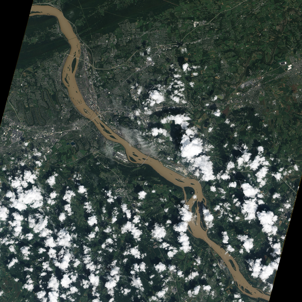
A satellite view of the Susquehanna River near Harrisburg, PA, on September 10 shows the high levels of sediment that are being carried toward Chesapeake Bay. Courtesy: Advanced Land Imager (ALI) on NASA’s Earth Observing-1 (EO-1) satellite.
The Stewards of the Lower Susquehanna, joined by the Waterkeepers Chesapeake, a coalition of 18 conservation groups throughout the Chesapeake Bay region, petitioned for intervention with FERC for the Conowingo Dam relicensing. The Stewards of the Lower Susquehanna’s, joined by the Waterkeepers Chesapeake, motion to intervene can be seen here. The article below provides a summary of their filing:
Seeking to lessen impacts of the Conowingo Dam on the bay
York Daily Record, Michael Helfrich, July 19, 2013

High suspended-sediment concentrations after Hurricane Ivan (September, 2004). NASA Terra satellite image taken September 21, 2004, shortly after Hurricane Ivan hit the Chesapeake Bay.
Flooding in the Susquehanna River Watershed
Click here to learn more about the historical repeat flooding incidents inflicting the Susquehanna River Watershed. Tropical Storm Agnes (1972) set the record crest for the Susquehanna River at 32.57 feet. Tropical Storm Lee (September 10, 2011) had a crest of 26.2 feet, which is the fourth highest on record.

Courtesy of USGS “Sediment Sources and Transport in the Chesapeake Bay Watershed”.
